History Blog
|
|
|
Editor’s Note: Welcome to the next episode in our 11-part account of Muddy Paddle's narrowboat trip through the Erie Canal and the Cayuga & Seneca Canal in western New York. The New York State Barge Canal system is in many ways a tributary of the Hudson River. It still connects the Great Lakes, the Finger Lakes, and Lake Champlain with the Atlantic Ocean by way of the Hudson River. Our contributing writer, Muddy Paddle, shares his experiences aboard the "Belle Mule." All the included illustrations are from his trip journal and sketchbooks. Day 5 - WednesdayWe had a restful night on the wall in Seneca Falls and woke up with much anticipation for a day on the Erie Canal. We had heavy fog as we made our way across Lake Van Cleef and lined up our approach to the locks 2 and 3 of the Cayuga and Seneca Canal. The combined locks drop boats a total of 49 feet. The lock chambers were turbulent and I had an awful time with our transmission trying unsuccessfully to keep the boat in position. Everyone kept yelling at me to keep the boat in neutral including the lock tender. Neutral, however, was only a state of mind. When the big steel doors opened at the bottom of Lock 2, an eddy on the swollen and swift flowing Seneca River got a hold of the Belle and we needed full throttle to regain steering and control. Fortunately, full throttle worked just fine. We barreled down the Seneca River with the flood waters for three miles and then briefly entered the north end of Cayuga Lake before finding the approach to Lock 1 at the lake’s outlet. A south turn would have taken us up the lake 40 miles to Ithaca. We entered Lock 1 with a New York State Canals buoy tender. The lock operator was especially friendly and good natured and maintained manicured lawns and plantings around the lock. Shauna came up on deck to help with the stern line and I stayed put at the pedestal trying to maintain our position with the shift lever. When the lock opened, we travelled north on the Seneca River alongside the Montezuma Wildlife Refuge. The river was high and we noticed some flooding and several sunken docks. We passed beneath the New York State Thruway to a roundabout of waterways including the mouth of the Clyde River, a short channel leading to the west-bound Erie Canal, and a short channel carrying the Seneca River and east-bound Erie Canal. We turned right to take a look at the ruins of the 900-foot long Richmond Aqueduct completed on the enlarged Erie Canal in 1857. All but seven of the aqueduct’s 31 stone arches were dynamited in 1917 when the Barge Canal was completed and traffic was routed from the aqueduct to the river. This was one of the longest of the aqueducts on the Erie Canal and remains one the canal’s most impressive and scenic engineering monuments. 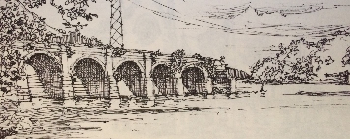 The ruins of the Richmond Aqueduct completed in 1857 and destroyed in 1917. We turned around and headed west on the Erie reaching Lock E-25 at May’s Point in a few minutes. May’s Point was a small tongue of dry land in the great Montezuma Swamp and an important landmark in the trackless swampland here for early travelers going west by boat and the workers forcing the original Erie Canal through the malarial swamps. Lock 25 features a steel arch gateway and remains an oasis surrounded by trees and lawns. After locking up, we traveled west along the artificially dug Barge Canal while observing the many channels and oxbows of the parallel Clyde River immediately to our south. We caught glimpses of the original but abandoned Erie Canal channel immediately to our north. We went through Lock E-26 just before arriving at the village of Clyde. 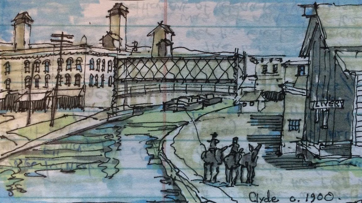 Clyde as it appeared around 1900 with canal boats passing beneath an open lift bridge. Clyde was settled in 1811 and named Lauraville in anticipation of our best friend Lora’s arrival aboard the Belle (just kidding of course!). A few years later, it was renamed Clyde by Scotsman Andrew McNab who also named the main business street Glasgow Street. The Erie Canal was built right through the settlement which became a bustling glass manufacturing center. When the Barge Canal was built in the early twentieth century, the old canal in town was abandoned and a new and larger channel was established a short distance to the south by straightening and dredging the Clyde River. There was a famous covered bridge over the river on Glasgow Street in the nineteenth century. We believe we observed one of its stone abutments as we continued our journey west. We continued along a heavily wooded stretch of canal interrupted by occasional and somewhat picturesque abandoned railroad bridge abutments festooned with grapevines and poison ivy. For about five miles, the canal parallels the old river with its tortured turns and loops which if traveled by boat would total ten or more miles. Shauna and Lora made soup and nachos for lunch. Soon, the village of Lyons came into view. Lyons was settled in 1789 at the fork of the head of the Clyde River where it was fed by the Canandaigua Outlet and the Ganargua or Mud Creek and named (tongue-in-cheek?) for the French city of Lyon at the fork of the Rhine and the Saone. Its French namesake seemed to have inspired architectural pretensions and the village subsequently developed a skyline with a domed courthouse, two substantial Gothic church towers with tall finials, and a three-story commercial block with a very fine wrought iron gallery at the corner. According to Rochester journalist Arch Merrill, 40 slaves were brought here from Maryland in 1797 to build a 1600 acre plantation for Daniel Dorsey complete with mansion and slave cabins. Lyons was established as the seat of Wayne County and its swampy lands became ideal for the culture of essential oils, particularly peppermint. Later in the nineteenth century, it became an important railroad town. The New York Central Railroad maintained car shops in Lyons until 1923. 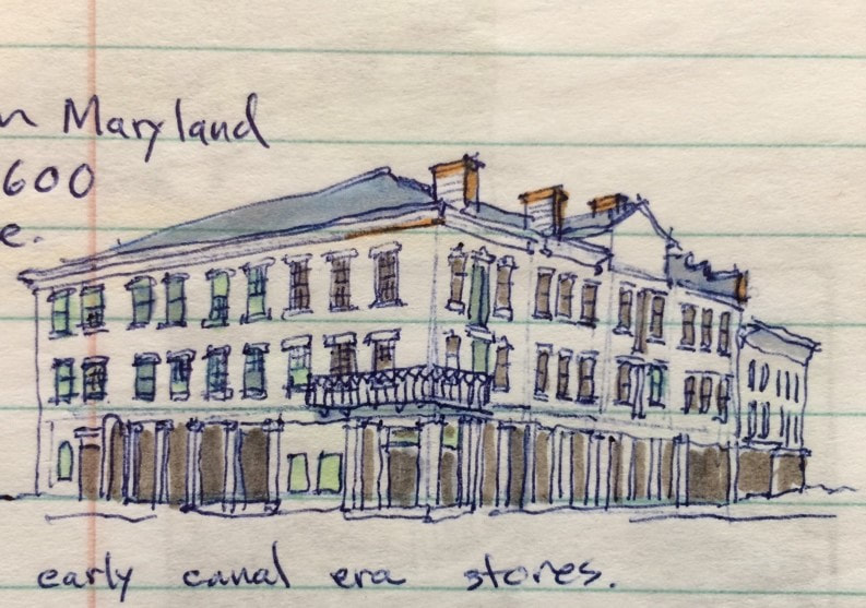 Erie Canal era stores in Lyons. We passed beneath the Geneva Street bridge and tied up on the wall near the approach to Lock E-27. The lock tender had already opened his gates to lock us up, so I called him on the radio to apologize and to let him know we were stopping in Lyons for a few hours. After connecting to shore power, we took a walk to the east side of town to visit the Trail of Hope. Aptly named, the serpentine trail and surrounding park were recently built by volunteers to offer children and the handicapped an opportunity to experience nature and to plant. We then walked into the town center where we visited the shops on William Street, got fresh coffee and searched unsuccessfully for some peppermint souvenirs. The Hotchkiss Essential Oils Company bottled peppermint oil here until about 20 years ago, shipping the concentrate in cobalt blue bottles and vials to candy and toothpaste manufacturers all over the world. One of their biggest customers was the Life Savers factory in Port Chester, NY, still decorated with larger-than-life peppermint Life Savers. The nineteenth century canal-side building has been preserved. 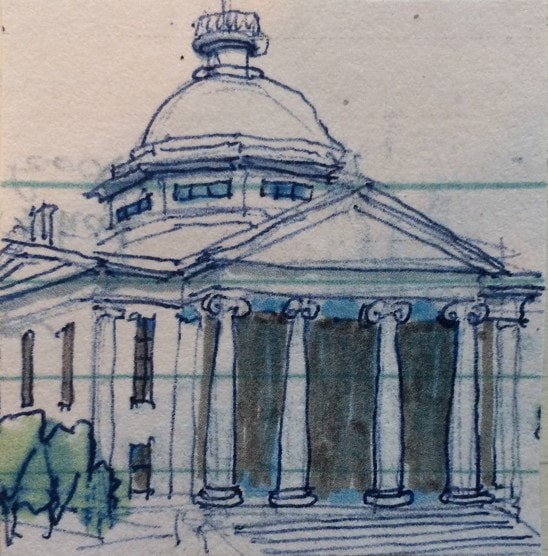 1854 Wayne County Courthouse We also went over to the courthouse square. One of the most sensational trials conducted in the Wayne County Courthouse was that of Oliver Curtis Perry who hijacked and robbed an express train in 1892 and made an escape by taking an idle locomotive away from the scene. He was chased, jumped off, stole a horse and sleigh, and then ran on foot. He was sentenced to 49 years, and later escaped from two prisons. The Utica Globe entitled its story of the trial “Startling Career, Desperate Deeds, Gifted Ruffian.” We returned to the Belle, and called the lock operator. He was at Lock E-28A and had to drive to E-27 to pass us west. After locking through, he drove back to E-28A to assist us there. Many lock operators manage two or more locks, shuttling between them by car or when close together by bicycle. Lock E-28A is located at the historic Lyons dry docks where canal tugs and barges are placed on blocks and repaired. Historic Dipper Dredge 3 sits in retirement here, a major artifact from the age of steam and the construction of the Barge Canal in the early twentieth century. The old “Poorhouse Lock” (old lock 56) from the 1840s is preserved here along with a brick canal store which is now a private residence. We could have spent at least an hour here, but the day was getting late and we were anxious to cover the few remaining miles to Newark. Several long freight trains ran parallel to the canal here and I was able to signal one in time for the engineer to blow the horn. We locked up through E-28B at the east end of Newark and docked on the wall in front of a village park with full boater services including showers and a laundromat. We had dinner at an Italian restaurant on Main Street. Back at the boat, Shauna baked cookies and we played a few rounds of Pictionary before calling it a night. AuthorMuddy Paddle grew up near the junction of the Hudson River and the Erie Canal. His deep interest in the canal goes back to childhood when a very elderly babysitter regaled him with stories about her childhood on the canal in the 1890s. Muddy spent his college years on the canal and spent many of his working years in a factory building overlooking the canal. Over the years he has traveled much of the canal system by boat and by bicycle. Muddy Paddle's Erie Canal adventure will return next Friday! To read other adventures by Muddy Paddle, see: Muddy Paddle: Able Seaman, about Muddy Paddle's adventures on the replica Half Moon, and Muddy Paddle's Excellent Adventure on the Hudson, about his canoe trip down the Hudson River.
The History Blog is supported by museum members and readers like you! Donate or join today!
0 Comments
Your comment will be posted after it is approved.
Leave a Reply. |
AuthorThis blog is written by Hudson River Maritime Museum staff, volunteers and guest contributors. Archives
July 2024
Categories
All
|
 RSS Feed