History Blog
|
|
|
Last week, we discussed the impacts of cholera and yellow fever on Rondout in the 1830s and ‘40s, but New York City underwent similar epidemics throughout the early 19th century. At the same time, rising population in New York City, as well as efforts to fill in its brackish wetlands and shorelines, was creating a problem with the water table and pollution. Fresh drinking water was becoming more and more scarce in the growing city and natural water sources were increasingly contaminated by sewage and industrial wastes.  "Sanitary & Topographical Map of the City and Island of New York" by Egbert Viele (1865). This groundbreaking map of Manhattan showed the original shoreline, water features, and wetlands underneath the streets of New York City. This map is still used by engineers today. Enter a pie-in-the-sky idea for yet another enormous engineering marvel (New York’s canals being the previous pipedreams turned reality) – the Croton Aqueduct. The idea was simple – pipe clean water from the relatively unspoiled Croton River through gravity-fed aqueducts to New York City. Aqueducts were certainly not a new idea – the Romans had invented them, after all – but to construct something on this scale was a rather startling idea. Following the cholera epidemic of 1832, Major David Bates Douglass, an engineering professor at West Point and one of a new school of civil engineers, surveyed the proposed route in 1833. Bates was an excellent surveyor, but had proposed no practical plans for physical structures, and so was fired in 1835. As early as 1835, before construction even began, the project was gaining national attention. An article from the Alexandria Gazette (Richmond, VA) from December 25, 1835 discussed the plan, writing, “In carrying into effect the contemplated plan of supplying the City of New York with water from the Croton River, an aqueduct, we believe, is necessary across one of the rivers. If this is so, the experience gained to that city and the county in submarine architecture, by the works now going on at the Potomac Aqueduct in connexion with the Alexandria Canal, will be invaluable.” 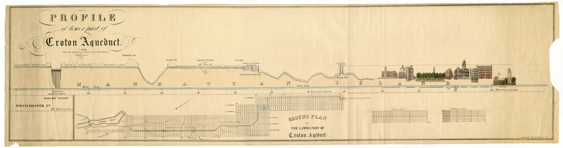 Profile and Ground Plan of the Lower Part of Croton Aqueduct. Date Unknown. Courtesy Jervis Public Library, Rome, NY. December, 1835 gave New York City another reason to want abundant supplies of water – the Great Fire of New York of 1835 wiped out most of New York City and bankrupted all but three of its fire insurance companies. The fire would spur a number of reforms, including an end to wooden buildings (a boon for the Hudson Valley’s brick, cement, and bluestone industries). But many wondered, had the aqueduct already been in place, if more of the city would have been saved. 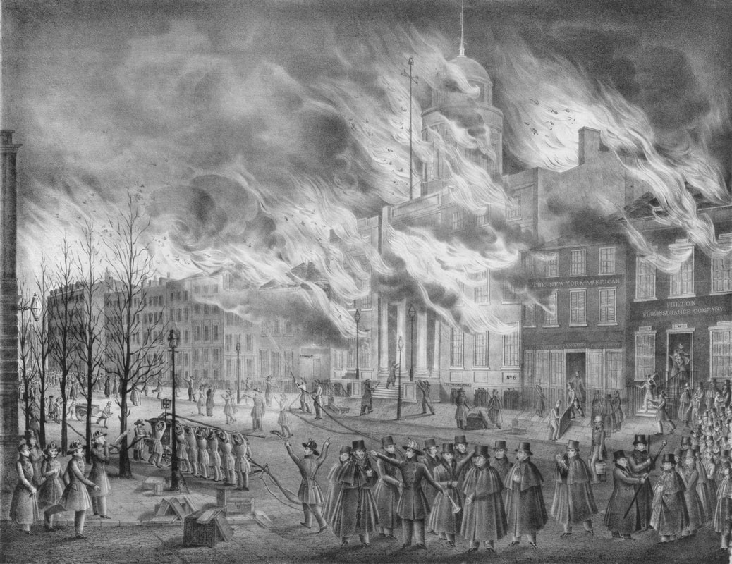 Lithograph showing the burning of the Merchant's Exchange Building during the Great Fire of New York, December 16-17 1835. Library of Congress. John B. Jervis, who cut his teeth on the construction of the Erie, D&H, and Chenango canals as well as early railroads, became Chief Engineer on the Croton Aqueduct project in 1836, and construction began the following year. The Croton River was dammed and thousands of laborers, many of them Irish, commenced digging tunnels by hand and lining them with brick. On August 22, 1838, the Vermont Telegraph published a good description of the work: “The Aqueduct which is to bring Croton river water into the city of New York, will be 40 miles long. It will have an unvarying ascent from the starting point, eight miles above Sing Sing to Harlem Heights, where it comes out at 114 feet above high water mark. A great army of men are now at work along the line, and at many points the aqueduct is completed. The bottom is an inverted arch of brick; the sides are laid with hewn stone in cement, then plastered on the inside, and then within the plaster a four inch brick wall is carried up to the stone wall, and thence the top is formed with an arch of double brick work. It will stand for ages a monument of the enterprise of the present generation.” 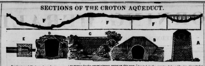 Illustration of Sections of the Croton Aqueduct, as published in the New York "Morning Herald" newspaper, September 4, 1839. On November 11, 1838, a newspaper in Liberty, Mississippi reported on a bricklaying contest – “In a match at brick-laying in a part of the arch of the Croton Aqueduct, between Nicholson, a young man of Connecticut, and Neagle, of Philadelphia, the latter was a head when his strength gave way, having laid 3,700 bricks in 5 ½ hours. Nicholson continued a half hour longer, when he had laid 5,350. The work was capitally done.” On September 12 of that same year, the Alexandria Gazette chimed in again, noting, “There are full four thousand men employed on the line of the Croton Aqueduct, which is to supply the city of New York with pure and wholesome water. About six of the sections will be completed this fall. The commissioners will now proceed to contract for the ‘Low Bridge’ across the Harlem river, according to the original plan. The whole, when finished, will be the most magnificent work in the United States.” #/media/File:45_William_England_-_High_Bridge,_Harlem_River,_New_York.jpg) Photo of High Bridge from, "An American Journey – The Photography of William England." Photo by William England, 1859. The Low Bridge the Gazette referred to was originally planned to go under the Harlem River, but this was quickly abandoned. Instead, what is now known as the High Bridge was constructed in stone – its arched support pillars strongly reminiscent of Roman aqueducts. High Bridge was designed by Chief Engineer John B. Jervis and completed in 1848. It remains the oldest bridge in New York City. Indeed, the High Bridge and the whole aqueduct warranted a lengthy newspaper article – almost the whole page – August 27, 1839 edition of the New York Morning Herald. Cataloging the extant Roman aqueducts around the world, defining the difference between an aqueduct and a viaduct (aqueducts carry water across water – viaducts carry water across roads), and in all comparing the Croton Aqueduct, and especially the High Bridge, quite favorably to all its predecessors. But not all was well in construction. The Morning Herald wrote extensively of the aqueduct again on September 4, 1839 claiming, “owing to the gross mismanagement that has prevailed in the office of the water commissioners, the expense of the work has been twice as much as it ought to have been, and after all it will be very defective in many of its most important points; and independent of the immense trouble and the large sums of money that will perpetually be required to keep the whole of it in repair, we have not the least doubt that, when the work comes to be proved by passing a large body of water through it, at least one-sixth part of it will have to be pulled down and rebuilt.” The article continues on in that vein for quite some time – the principal complaint besides cost being that, unlike the Romans (who also used better quality brick and cement), the Croton Aqueduct would be largely hidden from sight, and the iron pipes would “burst upon the first pressure,” claiming that the commissioners “wanted to oblige some friend who was an iron founder, and to give him a fat contract, by which he could get rid of a quantity of old metal.” Of course, the editor of the Morning Herald seemed to have ulterior motives, as he negatively connected the Croton Aqueduct with President Martin Van Buren’s campaign for reelection in July of that year, and blamed politicking for the delays and purported graft. He also seemed to hold a grudge – the Morning Herald reported endlessly about the aqueduct, but also about purported mismanagement. No other newspaper from the era reported similar claims. However, an article in the Richmond Gazette (Richmond, VA) from July 28, 1842, does hint at the enormous cost of the project, but brings up the 1835 fire and its enormous cost as a justification for the price.  Double Arch over Sing Sing Kill, Ossining, from a 1907 postcard; upper arch carries the aqueduct, the lower one carries a local street. At 5 A.M. on June 22, 1842, water began flowing through the Croton Aqueduct. The water commissioners, aboard the small vessel the Croton Maid of Croton Lake, went with it. The 16 foot long, four-person barge was especially built to traverse the tunnels and continued until High Bridge, which was not yet completed. On June 27, the Croton Maid was carried across the river and the commissioners continued back into the aqueduct, arriving at the York Hill Reservoir to a 38 artillery gun salute. The following day, the Board of Water Commissioners submitted a report to Robert H. Morris, the Mayor of New York City. It was printed in the New York Herald on June 25, 1842. “SIR – The Board of Water Commissioners have the honor to Report, that on Wednesday, the twenty second instant, they opened the gates of the Croton Aqueduct at its mouth, on the Croton Lake, at 5 o’clock in the morning, giving it a volume of water of 18 inches in depth. “The Commissioners, with their Chief and Principal Assistant Engineers, accompanied the water down, sometimes in their barge, ‘the Croton Maid of Croton Lake,’ and sometimes on the surface of the Aqueduct above. “We found that the water arrived at the waste gates at Sing Sing, a distance of 8 miles in 5 hours and 48 minutes: here we suffered the water to flow out at the waste gates until 12 o’clock, M., when the gates were closed on a volume of about 2 feet in depth. The water then flowed on and arrived at Mill River waste gates at a quarter past 3 o’clock, a distance of 5 miles. “It was there drawn off through the waste gates for half an hour, and was, at a quarter before 4 o’clock, allowed to flow on. We continued to precede it on land, and to accompany it in our boat, in the aqueduct, to Yonkers, a distance of 10 miles, where it arrived at half past 10 o’clock at night. Here we permitted it to flow at this waste gate until a quarter past 5 o’clock in the morning, when the waste gates were closed, and it flowed on and arrived at the waste gate on the Van Courtlandt farm, a distance of five miles and a half, in three hours and a quarter. Here we permitted it to flow out of the waste gates for two hours when the gates were closed, and it flowed, in two hours and twenty minutes, a distance of about four miles and three quarters, down to the Harlem river, where the Commissioners and their Chief Engineer emerged to the surface of the earth in their subterranean barge at 1 o’clock, June 23d. “The average current or flow of the water has been thus proved to be forty-five minutes to the mile, a velocity greater, we are happy to say, than the calculations gave reason to expect. “It is with great satisfaction we have to report, that the work at the dam, on the line of aqueduct proper, the waste gates and all the appendages of this great work, so far as tried by this performance, have been found to answer most perfectly the objects of their construction. “In conclusion, we congratulate the Common Council of the city, and our fellow citizens, at the apparent success of this magnificent undertaking, designed not for show, nor for luxury, nor for glory; but for health, security against fire, comfort, temperance [note: a reference to the habit of mixing New York water with alcohol to make it safe and palatable to drink] and enjoyment of our whole population – objects worth of a community of virtuous freemen. “With great respect, we remain, your obedient servants, Samuel Stevens, John D. Ward, Z. Ring, B. Birdsall. “P.S. – We expect the water will be admitted into the Northern Division of the Receiving Reservoir on Monday next, at half-past 4 o’clock, P.M. at which time and place we shall be happy to see yourself and the other members of the Common Council.” 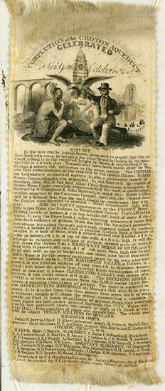 Silk souvenir ribbon from the opening of the Croton Aqueduct, October 14, 1842. Courtesy Westchester County Archives. In fact, the water did not begin to fill the Manhattan reservoirs until July 4, 1842. The official celebration was reserved for October 14, 1842. The New York Herald reported the following day, “The celebration commenced at daylight with the roar of one hundred cannon, and all the fountains in the city immediate began to send forth the limpid stream of the Croton. Soon after this, the joyous bells from a hundred steeples pealed forth their merry notes to usher in the subsequent scenes. At and before this moment, over half a million of souls leaped simultaneously from their slumbers and their beds, and dressed themselves as for a gladsome gala day – a general jubilee.” Workers were given the day off and an enormous parade, with representatives from every official organization in the city followed, ending at City Hall Park, where an enormous fountain was flowing. Again, the New York Herald, “For several days previous, thousands of strangers had been pouring into the city from all parts of the country, to see and join in the procession, until there must have been at least 200,000 strangers in the city, making an aggregate with the resident inhabitants of half a million of souls congregated in our streets.” The opening of the Croton Aqueduct marked a period of transformation for New York City. Already one of the most important port cities in the nation, the abundance of clean water meant that urban and industrial growth could continue apace. The aqueduct was expanded several times, but in 1885 the “New Croton Aqueduct” was constructed. The Old Croton Aqueduct continued to be used until the 1950s, and is today a park – many of its old aqueduct bridges are now pedestrian bridges, as had been suggested during their original construction. The New Croton Aqueduct is still in use, still bringing Croton River water to New York City. #/media/File:High_Bridge,_New_York_City,_1900.jpg) High Bridge in 1900, with the original stone arches crossing the Harlem River.  High Bridge in 2009, with the replacement steel arch over the Harlem River. Photo by Jim Henderson. The High Bridge across the Harlem River, completed in 1848, was threatened with demolition in the 1920s. The narrow support arches were thought to impede commercial traffic on the Harlem River, and water was no longer flowing across the bridge, instead using a tunnel drilled beneath the Harlem River (also as originally planned). Architects and preservationists fought to save the bridge and in 1927, a compromise was reached – the bridge would remain, but five of the center stone arches were replaced with a single span of steel. In 1968, the Old Croton Aqueduct State Historic Park was established to preserve the original route of the aqueduct through Westchester County. In 1992, the Old Croton Aqueduct was designated a National Historic Landmark. AuthorSarah Wassberg Johnson is the Director of Exhibits & Outreach at the Hudson River Maritime Museum, where she has worked since 2012. She has an MA in Public History from the University at Albany. If you enjoyed this post and would like to support more history blog content, please make a donation to the Hudson River Maritime Museum or become a member today!
0 Comments
Your comment will be posted after it is approved.
Leave a Reply. |
AuthorThis blog is written by Hudson River Maritime Museum staff, volunteers and guest contributors. Archives
July 2024
Categories
All
|
 RSS Feed